Mapping a Virus: Visualizing COVID-19 in Michigan

Mapping a Virus: Visualizing COVID-19 in Michigan
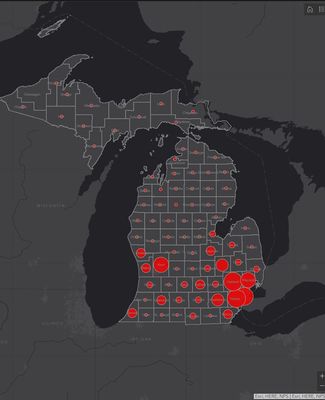
As cases of the novel coronavirus began spreading across the globe earlier this year, Jonnell Sanciangco created a dashboard displaying realtime statewide data.
July 20, 2020As cases of the novel coronavirus began spreading across the globe earlier this year, Jonnell Sanciangco, a Michigan State University doctoral candidate specializing in spatial methodologies in the Department of Geography, Environment and Spatial Sciences, began a routine of checking one of the few websites sharing daily COVID-19-related data at the time. The Coronavirus Resource Center website, popular among his colleagues, is hosted by the Johns Hopkins University Center for Systems Science and Engineering, and features an ArcGIS dash-board—a configurable geographic information system web application that allows users to present real-time data via charts, graphs, maps, gauges and other visual elements. When the first cases of the virus were detected in Michigan, Sanciangco, an expert in GIS, wondered if a similar dashboard focused solely on the state could be of use to local health care, government officials and other interest-ed parties, especially those needing to make decisions related to the outbreak.
“I was thinking about it all night, and I told my wife, ‘You know, I can do this. I can put up a similar dashboard using just the Michigan data that is publicly available from the state.’ So she dared me to do it, and the next day I started putting it together,” said Sanciangco.
Sanciangco’s Michigan COVID-19 dashboard is updated daily with information provided by the state. The panel features data at the state and county level, and users can explore the information based on demographic characteristics such as sex, age groups, race and ethnicity. The dashboard is publicly available on the Space, Health and Community (SHAC) Lab website. The SHAC Lab in the Department of Geography, Environment and Spatial Sciences at MSU is a research laboratory that concentrates on the geographic and equity dimensions of public health and public health policy.
Contributing Writer(s): Diane Huhn, Caroline Brooks


